
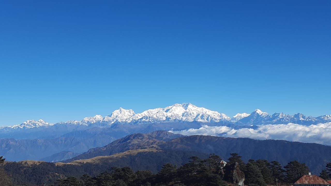
The Sandakphu Trek is the highest trekking route in West Bengal, rising to an altitude of 3,636 meters (11,929 ft) and offering something no other Indian trek can—a single panoramic viewpoint of four of the world’s five highest peaks: Mt. Everest, Kanchenjunga, Lhotse, and Makalu. This legendary skyline formation is famously known as the Sleeping Buddha, a natural phenomenon that makes Sandakphu one of the most photographed trekking destinations in the Sikkim and Darjeeling Himalaya.
Discover the world's highest peaks, hidden red pandas, and legendary hospitality on an unforgettable border-ridge walk
⚡ Sandakphu Trek At a Glance
Sandakphu Trek lies inside the Singalila National Park, a globally important biodiversity hotspot and a protected Red Panda Conservation Zone. Unlike most Himalayan treks, Sandakphu uniquely allows both DIY Sandakphu Trek routes and guided experiences, along with the famous Singalila Land Rover Tour—making it accessible to a wide range of travelers.
Why Choose Sandakphu?
Unlike the rugged, isolated trails of the Everest region, the Sandakphu route is dotted with tea houses and Indo-Nepal border markers. The trail crosses between Nepal and India multiple times in places.
At Super Trekkers, we highlight this trek for families and first-timers because it pairs big mountain views with a moderate physical challenge.
The route also passes through Singalila National Park, a protected biodiversity hotspot and Red Panda Conservation Zone. Trekkers can plan a DIY route or choose a guided experience; current guide rules should be confirmed before travel.
Best Time to Visit Sandakphu
Conditions and views vary by month. Regular trekking and Land Rover movement inside Singalila National Park are stated to close from mid-June to mid-September; confirm current access before travelling.
| Month | Temperature (high / low) | View / vibe |
|---|---|---|
| March–April | 15°C / 2°C | Rhododendron and magnolia blooms. |
| May | 18°C / 5°C | Clear mornings and misty afternoons. |
| October–November | 10°C / −5°C | Best visibility and clear Himalayan peak views. |
| December–January | 5°C / −10°C | Heavy snow; winter conditions. |
Essential Permits, Costs & Legal Requirements
Permits are obtained at the Manebhanjan checkpost. The supplied draft lists typical office hours as 6:00 AM–6:00 PM. Fees, office hours and documentation may change; confirm current requirements with the relevant authorities before travel.
| Permit / item | Purpose | Approximate cost in supplied draft | Documents / notes |
|---|---|---|---|
| Singalila National Park entry permit | Entry and trekking in the park. | ₹100–₹200 per person; another passage says ₹200 for Indians and ₹500 for foreigners. | Original photo ID (passport for foreigners; Aadhaar or voter ID for Indians); 2–4 passport-size photos. |
| Trekkers’ registration card | Register itinerary and track movement in the border area. | ₹50–₹100 per person. | Route and tea-house stay details may be required. |
| Camera fees | Camera entry charges. | Digital still: ₹100; video: ₹400. | Confirm current charges at the checkpost. |
| Nepal trail sections | Some trail sections briefly pass through Nepal. | The draft says usually covered by other fees; no formal visa needed for these trail sections. | Carry your passport and follow border officials’ instructions. |
Carry an original Aadhaar card or passport and four passport-size photos, as advised in the supplied draft.
Day-by-Day Itinerary
Day 1: Arrival in Manebhanjan (2,150 m)
Arrive at the gateway to Singalila National Park, usually travelling from NJP or Bagdogra.
- Highlight: Final gear check and briefing with local leads.
Day 2: Manebhanjan to Tumling (2,970 m)
- Distance / time: 11 km / 6 hours.
- The ascent: Steep climb to Chitrey, the hardest part of the day.
- Stay: Tea houses in Tumling, Nepal side.
Day 3: Tumling to Kalapokhri (3,186 m)
- Distance / time: 14 km / 7 hours.
- Highlight: Red Panda Conservation zones; look out near bamboo thickets.
- Water: Refill at Gairibas.
Day 4: Kalapokhri to Sandakphu (3,636 m)
- Distance / time: 6 km / 4 hours.
- The push: Short, steep ascent rewarded with a 180-degree Sleeping Buddha view.
- Tip: The draft recommends arriving by 2:00 PM for sunset.
Day 5: Sandakphu to Phalut (3,600 m)
- Distance / time: 21 km / 9 hours.
- Terrain: Mostly flat ridge walking; described as the most scenic day.
Day 6: Phalut to Gorkhey (2,300 m)
- Distance / time: 15 km / 6 hours.
- Descent: Through forests of chestnut and pine.
Difficulty & Fitness Requirements
The Sandakphu trek is rated moderate. You do not need technical climbing skills, but you do need the stamina to walk 5 to 9 hours a day for several days in a row, often on steep, rocky or uneven trail. The highest point is 3,636 m (11,929 ft), so altitude and cold matter more than technical difficulty.
How hard is each day?
| Day | Distance / time | Effort | What to expect |
|---|---|---|---|
| Day 1: Manebhanjan | Arrival and briefing | Easy | No trekking. Check gear and rest before the climb. |
| Day 2: Manebhanjan to Tumling | 11 km / about 6 hrs | Moderate to hard | Steady climb with a steep section up to Chitrey. Pace yourself early. |
| Day 3: Tumling to Kalipokhri | 14 km / about 7 hrs | Moderate | Rolling ridge trail through forest. Long but not steep. |
| Day 4: Kalipokhri to Sandakphu | 6 km / about 4 hrs | Hard | Short but steep final ascent at the highest altitude of the trek. |
| Day 5: Sandakphu to Phalut | 21 km / about 9 hrs | Moderate | Mostly gentle ridge walking, but the distance makes it the longest day. |
| Day 6: Phalut to Gorkhey | 15 km / about 6 hrs | Moderate | Long descent through forest. Strong knees and trekking poles help. |
Effort ratings are our own assessment for a fit beginner in good weather. Snow, rain or fog can make any day harder.
Who is this trek suitable for?
- First-time Himalayan trekkers who are active and can walk for several hours without stopping.
- Families with older children who are used to long walks. Check the daily distances above before you decide.
- Not recommended without medical advice: anyone with heart, lung or blood-pressure conditions, or a history of altitude illness. Talk to your doctor before booking.
How to prepare: 6-week fitness plan
Cardio, 3 to 4 days a week
Brisk walking, jogging, cycling or swimming for 30 to 45 minutes. Build toward a 60-minute session by week 4.
Legs and core, 2 days a week
Squats, lunges, step-ups and planks. Strong legs and a stable core make steep ascents and long descents easier.
Stairs or hill walks
Climb stairs or a hill with a loaded daypack once or twice a week to simulate the Chitrey and Sandakphu climbs.
Weekend practice hikes
Do one 4 to 6 hour hike every weekend in the final 3 weeks, wearing the boots and pack you will use on the trek.
Need a full routine? Follow our guide on how to prepare for a high-altitude trek. If this is your first Himalayan trek, you can also build stamina on the Kuari Pass trek first.
Altitude and cold
Sandakphu is lower than most Everest-region treks, but you still sleep above 3,000 m on several nights. Altitude sickness can affect any trekker, regardless of fitness.
- Walk slowly, drink water regularly and eat even when you have little appetite.
- Tell your guide straight away if you get a persistent headache, nausea, dizziness or unusual tiredness.
- Do not climb higher while symptoms are getting worse. Descending is the safest response.
- Pack layers. Nights near Sandakphu can drop below freezing in winter, and from late autumn to early spring temperatures at the top can be well below 0°C.
Not sure if you are ready? Tell us your fitness level and travel dates, and our team will recommend the right season, pace and itinerary. Contact Super Trekkers to plan your Sandakphu trek.


This is one of the most clear and practical guides to Sandakphu I’ve come across. The way you’ve explained the routes, permits, and day-wise plan makes it much easier for first-timers to actually picture the trek. That Sleeping Buddha view alone feels worth the effort.