The Gaumukh Tapovan Trek is a highly revered and challenging journey in the Garhwal Himalayas of Uttarakhand, India. It’s renowned for its spiritual significance as the source of the Bhagirathi River (a major tributary of the holy Ganga) and its breathtaking natural beauty, featuring towering peaks, diverse flora and fauna, and glacial landscapes. This briefing document synthesizes key information from various sources to provide a detailed overview of the trek, including its religious importance, environmental aspects, itinerary, essential gear, safety considerations, and best times to visit.
The Gaumukh Tapovan Trek is one of the most breathtaking Himalayan journeys in India, combining spiritual significance, glacier adventure, and stunning high-altitude landscapes. Located in Uttarkashi district of Uttarakhand, this trek takes you to the source of the River Ganga at Gaumukh Glacier and the majestic Tapovan meadows that offer close-up views of Mount Shivling, the Bhagirathi peaks, and several other Himalayan giants.
Unlike commercial Himalayan trails, this trek offers a raw wilderness experience, filled with glaciers, moraines, steep climbs, and sacred sites. It is equally popular among pilgrims, trekkers, photographers, and spiritual seekers. But it is also demanding, requiring good preparation, fitness, and reliable guidance.
Gaumukh Tapovan Trek: Trek Facts
| Aspect | Details |
|---|---|
| 📍 Location | Gangotri National Park, Uttarakhand, India |
| ⛰️ Max Altitude | Tapovan (4,463m) |
| 📏 Distance | 46 km (round trip) |
| ⏱️ Duration | 6-8 days (excl. travel to Gangotri) |
| ⚡ Difficulty | Moderate-Challenging (glacier crossing + altitude gain) |
| 🌤️ Best Season | May-June (spring) / Sept-Oct (autumn) |
| 🚫 Avoid | Monsoon (July-Aug: landslides) & Winter (Nov-Apr: extreme cold/avalanches) |
Religious & Cultural Significance
The Gaumukh Tapovan Trek is not just about natural beauty—it’s deeply tied to Hindu mythology and spirituality.
- Gaumukh Glacier is revered as the origin of the holy Ganga, considered the lifeline of India. Pilgrims believe that taking a dip in its icy waters washes away sins.
- Tapovan, meaning “forest of meditation,” has been home to sages and ascetics for centuries. Even today, sadhus meditate in caves around the meadow.
- Gangotri Temple is one of the Char Dham shrines and an important stop for Hindu pilgrims.
This spiritual aura makes the trek a blend of adventure and divine experience.
Key Highlights & Sights
Gangotri National Park
- Largest protected area in Uttarakhand (2,390 km²).
- Home to the Gangotri Glacier and source of the Ganga River.
- A biodiversity hotspot with rare species like snow leopard, blue sheep (bharal), and Himalayan tahr.
- Entry is strictly controlled with limited permits per day.
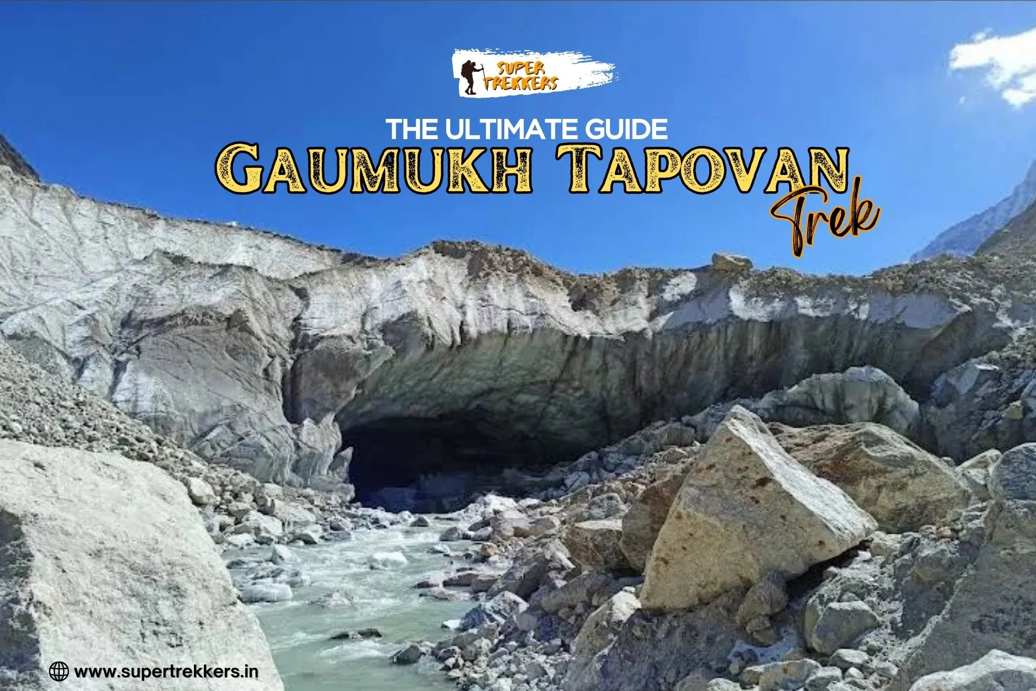
Gaumukh Glacier (12,760 ft)
The glacier snout resembles a cow’s mouth (hence the name). Witnessing the mighty Ganga emerging from this icy cavern is an unforgettable sight.


Tapovan Meadows (14,202 ft)
Known as one of the most beautiful alpine meadows in the Himalayas, Tapovan is surrounded by Shivling, Bhagirathi I–III, and Meru peaks.

Shivling Peak (6,543 m)
The dramatic pyramid-shaped peak dominates the skyline from Tapovan, often called the “Matterhorn of the Himalayas.”
Bhagirathi Peaks
These three massive peaks add grandeur to the trek’s landscape.


Trek Route & Itinerary
7-day standard itinerary for the Gaumukh Tapovan Trek
- Day 1: Dehradun → Uttarkashi (225 km drive, 8–9 hours)
- Day 2: Uttarkashi → Gangotri (100 km drive) → Acclimatization walk
- Day 3: Gangotri (10,055 ft) → Bhojbasa (12,450 ft, 14 km trek)
- Day 4: Bhojbasa → Gaumukh (12,760 ft) → Tapovan (14,202 ft, ~10 km trek)
- Day 5: Tapovan Exploration (Shivling, Bhagirathi Peaks, meditation caves)
- Day 6: Tapovan → Bhojbasa → Gangotri (~24 km descent)
- Day 7: Gangotri → Dehradun drive
Midpoint: Bhojbasa (3,780m)
Highlight: Gaumukh (3,940m)
Peak: Tapovan (4,460m)
- Day 1: Acclimatize at Gangotri
- Day 2: Trek to Chirbasa (3,600m)
- Day 3: Trek to Bhojbasa (3,780m)
- Day 4: Trek to Tapovan via Gaumukh
- Return via same route
Cross major river via manual trolley for safety.
Best Time to Visit Gaumukh Tapovan Trek
The Gaumukh Tapovan Trek is open only for a few months each year, as extreme Himalayan winters and heavy monsoons make the trail inaccessible. Trekkers typically plan their journey in two prime windows – Summer (May to mid-June) and Post-Monsoon/Autumn (mid-September to mid-October). Each season offers a different experience, and the choice depends on your preferences for weather, scenery, and trekking conditions.
🌞 Summer Season (Early May to Mid-June)
- Weather: Pleasant daytime temperatures range between 15°C to 22°C, while nights can dip close to 0°C. Early in the season, you may still find snow patches along the trail and at Tapovan.
- Advantages:
- Trail conditions are stable with fewer weather-related interruptions.
- Ideal for trekkers who enjoy walking through lingering snow.
- Disadvantages:
- Heavy road traffic due to the Char Dham Yatra pilgrimage season.
- Monsoon usually sets in by mid-June, bringing landslide risks. Trekking after June 20th is not recommended.
🍂 Post-Monsoon / Autumn Season (Mid-September to Mid-October)
- Weather: Day temperatures hover around 15°C, but at Tapovan nights are much colder, dipping to -3°C to -5°C. Clear skies dominate this season, making it one of the best times for mountain views.
- Advantages:
- Stunning post-monsoon landscapes—lush greenery, blooming flowers, and crisp air.
- Reduced road congestion, as this is outside the Char Dham peak rush.
- Brilliant autumn colors across the valley: yellows, browns, and maroons.
- Possibility of witnessing fresh snowfall in mid-October.
- Disadvantages:
- Much colder nights at higher altitudes.
- The trekking window is short, closing by mid-October as pre-winter snow sets in.
🌧️ Monsoon Season (July to Early September)
- Why to Avoid:
- Heavy rainfall makes the trails muddy, slippery, and dangerous.
- High risk of landslides, flash floods, and roadblocks.
- Limited visibility due to cloud cover.
Despite this, pilgrims may still visit Gaumukh during the season, but it’s unsafe for trekking to Tapovan.
Route Map – Gaumukh Tapovan Trek
The Gaumukh Tapovan Trek is a journey of immense spiritual significance and adventure, leading to the source of the holy River Ganga in the Garhwal Himalayas of Uttarakhand. It takes trekkers through the stunning landscapes of the Gangotri National Park, offering breathtaking views of towering peaks like Mt. Shivling and the Bhagirathi sisters.
The journey begins from Gangotri, a sacred temple town that also serves as the base camp, situated at an altitude of approximately 10,050 feet (3,065m)
Gaumukh Tapovan Trek Route map you can export GPX file
💡 Download offline maps or use GPS-based apps like Maps.me
Safety Advice
- Altitude Precaution: Acclimatize properly to avoid AMS (Acute Mountain Sickness).
- Weather: Carry rain protection even in summer. Nights are freezing, even in May–June.
- Glacier Navigation: Use a local guide or join a group like Super Trekkers for safety on icy terrain.
- Emergency Prep: Carry a first aid kit, ORS, Diamox (only if prescribed), and torch.
- Sustainable Trekking: No littering. Bring back plastic waste. Respect the sanctity of the Ganga.
Planning Tips
✅ Permits: Entry permit required for Gangotri National Park (limited entries per day). Foreigners need additional clearances.
✅ Fitness: Good physical fitness is a must—practice cardio, endurance, and strength training.
✅ Gear: Trekking shoes, layered clothing, windproof jackets, UV sunglasses, walking poles, crampons (if in early season).
✅ Accommodation: Guesthouses at Gangotri, tents at Bhojbasa & Tapovan.
✅ Connectivity: No network beyond Gangotri. Carry power banks & offline maps.
✅ Logistics: Pack enough dry fruits, snacks, and energy bars. Drinking water is available from streams (carry purifier tablets).
How to Reach Gaumukh Tapovan Trek
The Gaumukh Tapovan Trek begins from Gangotri (3,100 m), a sacred town in Uttarkashi district of Uttarakhand. Getting to Gangotri involves a combination of road, rail, and air travel. Here’s the detailed route:
🛫 By Air (Nearest Airport – Dehradun)
- Nearest Airport: Jolly Grant Airport, Dehradun (approx. 250 km from Gangotri)
- Connectivity: Well-connected with regular flights from Delhi, Mumbai, Bengaluru, Kolkata, and other major cities.
- From Airport to Gangotri:
- Hire a taxi/private cab directly to Gangotri (9–10 hours).
- Or take a cab/bus to Uttarkashi (6 hours) and then continue another 5 hours by road to Gangotri.
🚆 By Train (Nearest Railway Stations)
There’s no direct train to Gangotri. The nearest major railway stations are:
- Dehradun Railway Station (approx. 240 km from Gangotri)
- Well connected with Delhi, Varanasi, Mumbai, and Lucknow.
- Rishikesh Railway Station (approx. 230 km from Gangotri)
- Connected with Delhi and Haridwar.
From the railway stations:
- Taxis and buses are available to Uttarkashi / Gangotri.
- Travel time: 9–10 hours by road.
🚌 By Road (Direct Road Access)
- From Delhi to Gangotri: ~500 km (12–14 hours drive).
- Popular Route: Delhi → Haridwar/Rishikesh → Uttarkashi → Gangotri.
- Options:
- Private Cabs / Shared Jeeps: Comfortable but costlier.
- Buses: State-run (UKRTC) and private buses operate regularly from Haridwar, Rishikesh, and Dehradun to Uttarkashi and further to Gangotri (seasonal, mainly May–October).
📍 Road Distance Guide to Gangotri
- Dehradun → Gangotri: 240 km (9–10 hours)
- Rishikesh → Gangotri: 230 km (9–10 hours)
- Haridwar → Gangotri: 290 km (10–11 hours)
- Delhi → Gangotri: 500 km (12–14 hours)
🗺️ Final Leg: Uttarkashi to Gangotri
- Distance: ~100 km
- Duration: 4–5 hours by road.
- Transport Options: Shared jeeps, taxis, and seasonal buses available.
Frequently Asked Questions – Gaumukh Tapovan Trek
1. What is the best time to do the Gaumukh Tapovan Trek?
The best time is early May to mid-June and mid-September to mid-October, when the weather is stable and trails are open.
2. Is Gaumukh Tapovan Trek safe during the monsoon season?
No. The trek is not recommended from July to early September due to landslides, floods, and slippery trails.
3. How difficult is the Gaumukh Tapovan Trek?
It is a moderate to difficult trek with steep ascents, glacier crossings, and high altitude (up to 4,463 m at Tapovan).
4. How many days are required for Gaumukh Tapovan Trek?
Typically, 7–8 days including travel to and from Gangotri.
5. What permits are needed for Gaumukh Tapovan Trek?
Trekkers need a permit from the Forest Department (Gangotri National Park entry permit), which is limited in number.
6. Is a guide mandatory for Gaumukh Tapovan Trek?
Yes. As per government rules, you must trek with a registered guide/agency inside Gangotri National Park.
7. Can beginners do the Gaumukh Tapovan Trek?
Yes, but only if they have good fitness, prior trekking experience at moderate altitude, and proper guidance.
8. What is the highest altitude of the Gaumukh Tapovan Trek?
The highest point is Tapovan at ~4,463 meters (14,640 ft).
9. How cold does it get at Tapovan?
At night, temperatures can dip to -3°C to -5°C in autumn and close to 0°C in summer.
10. Is camping allowed on the Gaumukh Tapovan Trek?
Yes, camping is allowed at designated sites like Bhojbasa and Tapovan, but only with valid permits.
11. How to reach the starting point of Gaumukh Tapovan Trek?
The trek starts from Gangotri, which is accessible by road from Dehradun, Rishikesh, and Haridwar.
12. Are there tea houses or lodges on the trek?
Only a GMVN guest house at Bhojbasa; otherwise, trekkers stay in tents.
13. Is it safe to drink water from the Bhagirathi River?
No. Carry water purification tablets/filters as glacier water may contain sediments.
14. What kind of fitness is required for this trek?
You should be able to jog 4–5 km in 30 minutes and do endurance training before the trek.
15. Can I see Mount Shivling from Tapovan?
Yes, Mount Shivling (6,543 m) is clearly visible from Tapovan and is a highlight of the trek.
16. Is Gaumukh really the origin of River Ganga?
Yes, Gaumukh Glacier is the primary source of the River Bhagirathi, which later merges with Alaknanda to form the Ganga.
17. Are mules or porters available for carrying luggage?
Yes, porters and mules are available at Gangotri but must be booked in advance.
18. Do mobile networks work on the Gaumukh Tapovan Trek?
No mobile network beyond Gangotri. Carry a satellite phone (available with forest officials/trek leaders).
19. Is altitude sickness common on this trek?
Yes, due to high altitude. Proper acclimatization and hydration are essential.
20. What is the total trekking distance of Gaumukh Tapovan?
The trek covers ~46 km round trip (Gangotri → Tapovan → return).
Similar Trek
Other Trek Guides
- Annapurna Base Camp Trek vs Everest Base Camp Trek – Complete Comparison Guide
- Kedarkantha Trek: Ultimate Guide for Adventure Seekers
- Valley of Flowers Trek
- Exploring Mount Kilimanjaro: The Complete Trekking Guide
- Kuari Pass Trek Guide – Complete Itinerary, Routes, and Planning Tips
- Dayara Bugyal Trek – A Complete Travel Guide to Uttarakhand’s Hidden Gem


